
Nitrogen Deposition – LTC
Nitrogen deposition features in the latest Lower Thames Crossing Local Refinement Consultation. In easier terms this is when vehicles emit nitrogen and it enters the atmosphere and when it lands back onto the soil or into the water below it can create pollution issues and have negative impacts. They say they have reviewed this issue following a request from them to do so from Natural England (government body), and due to new assessment methodology as a result of the latest scientific opinions and discussions.
This update is a bit longer, but make no mistake this is a very important aspect, so please do have a read and most importantly have your say in your consultation response please!
Nitrogen deposition assessment
When reading the info on nitrogen deposition presented in this consultation it is important to remember that National Highways have not actually completed their assessments on this aspect yet. Is it right for them to be consulting us on something they haven’t even finished assessing and therefore cannot share adequate info with us to allow us the opportunity to make considered meaningful responses? We don’t think so.
It is also worth questioning how NH are stating in the consultation guide that the construction of the proposed LTC would have no significant impact on nitrogen deposition. Since there are no guarantees that they wouldn’t be using fossil fuel machinery and equipment during construction, if the project goes ahead, we do have to ask how they feel they can make such claims. We have asked them and are waiting on a reply.
What impact would nitrogen deposition have?
According to NH they are assessing 136 designated sites in regards to nitrogen deposition, and of those they say that 60 would be at risk of significant nitrogen deposition effects. The sites they are assessing can be seen in the map below, click to enlarge.
They say the combined area of the significantly affected designated sites is approx 250 hectares, but that this is subject to change as they work on further assessment.
They have identified clusters in two main locations south of the river. Along the A2 and M2 between the A2/M2 junction with the LTC and junction 2 of the M2 ( for the A228). And around junction 2 of the M2 and the A229 at Blue Bell Hill.
To the north of the river they say that the sites that would be impacted are more scattered, but they have identified two clusters. These are mainly adjacent to the proposed LTC route and consists of a Site of Special Scientific Interest (SSSI), five ancient woodlands, five local wildlife sites, and a veteran tree. The map is not that detailed to really be able to properly identify all sites easily.
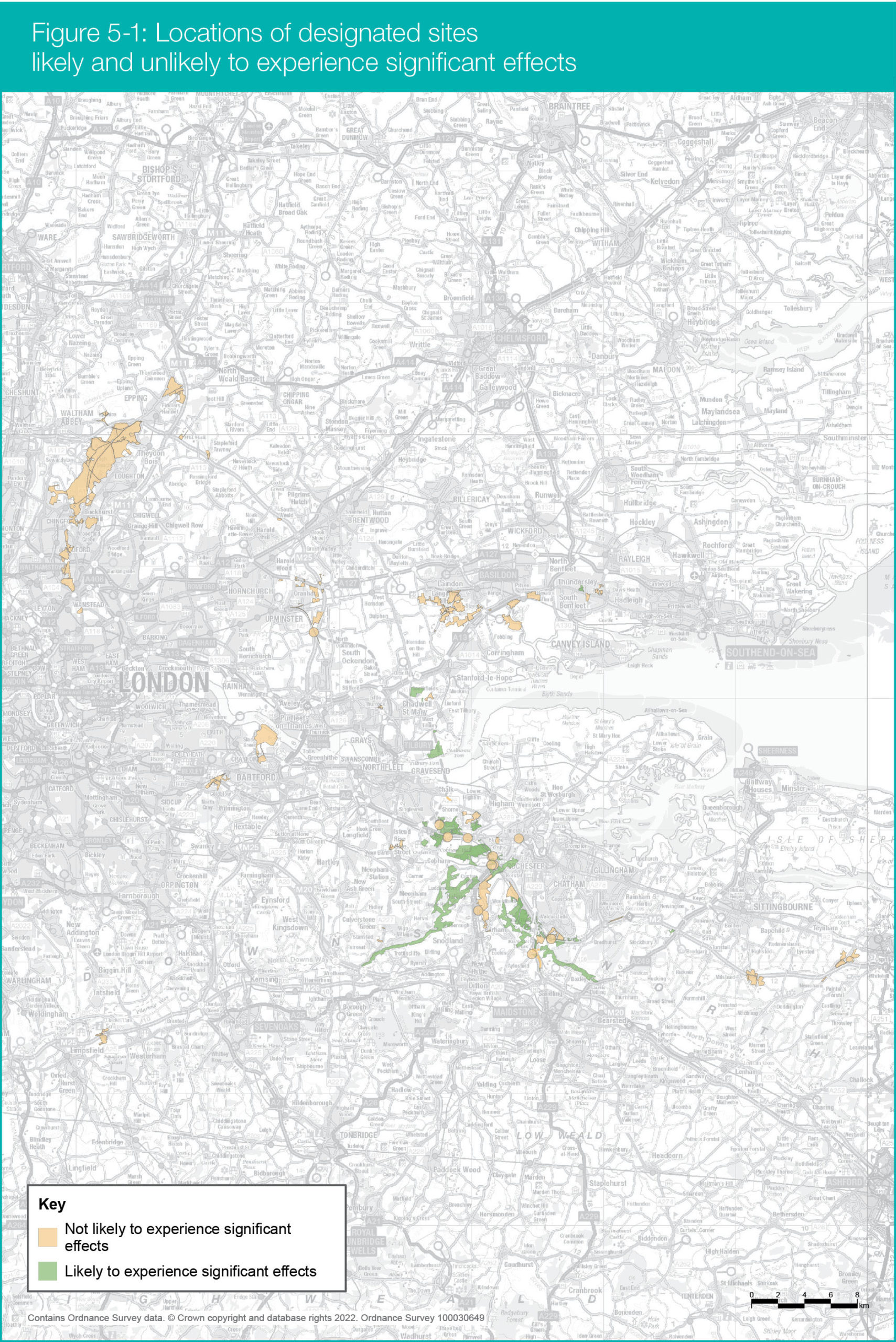
One designated site that gets a notable mention is Epping Forest Special Area of Conservation. This may seem like a site that is some distance from the proposed LTC, it is shown towards the top left of the map above. National Highways say that they don’t believe the site would experience significant effects because of nitrogen deposition associated with the LTC. Yet they admit that Natural England and others do not agree with NH’s assessment and they consider mitigation to be necessary.
National Highways say they have investigated reducing the speed limit from 70mph to 60mph on the M25 westbound between junctions 27 and 26 for four years from the Lower Thames Crossing opening as a form of mitigation. NH believe their assessment shows that this would have the effect of reducing nitrogen deposition, but that they do not consider this measure necessary and so they are not proposing it.
It is ludicrous that the government body that is responsible for ensuring England’s natural environment is protected are expressing concerns over the impacts to sites like Epping Forest Special Area of Conservation, and that National Highways (also a government company remember) are going against the advice and concerns of Natural England.
It is also worth considering that if the likes of Natural England are concerned about impacts to a site that is a distance away from the main proposed LTC route what impacts could there be closer to the route that NH may be overlooking or ignoring?
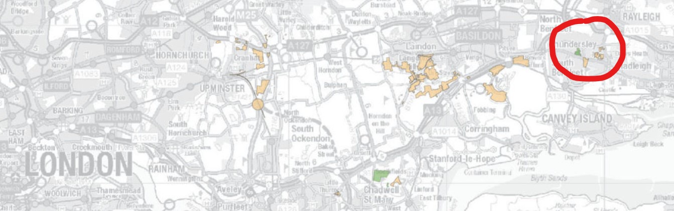
In addition, some sites and detail seem to be quite random and do not make sense. For instance why is there a site in the South Benfleet area which appears to be shown as a designated site that would likely experience significant effects of nitrogen deposition. Click image below to enlarge.
We have emailed NH to ask about this!
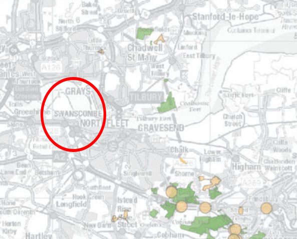
We also asked why some key sites, like Swanscombe Peninsula with it’s Site of Special Scientific Interest (SSSI) status are not identified on the map/assessments.
In the instance of Swanscombe Peninsula SSSI we would also question the likelihood of impacts especially at times when traffic would need to migrate between the two crossings due to incidents, because as we know the congestion and pollution would be extremely bad due to the lack of adequate connections.
Possible mitigation
National Highways say they have considered two forms of mitigation for nitrogen deposition – speed reduction/enforcement, and the use of 9m barriers – but state that both are not viable in regard to nitrogen deposition associated with the proposed LTC, and have been ruled out.
It appears that they are still considering speed enforcement though on a stretch of the M2 between junctions 4 and 3, which is to the east of the A229 (Blue Bell Hill). 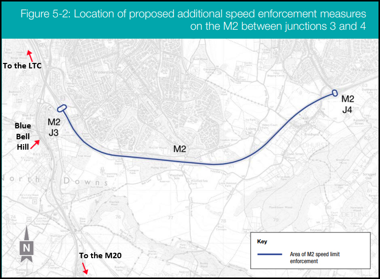
We find this strange, and are asking more questions on this. Their own data shows that the increase in traffic, if the proposed LTC goes ahead, would be greater on the A229/Blue Bell Hill than this section of the M2, because traffic on the M20 would use Blue Bell Hill/A229 to cut through to the M2 to head west to the LTC.
Why do they think, as they state in the consultation guide, that traffic is more likely to speed between junctions 3 and 4 on the M2 if the LTC goes ahead?
What is the reasoning for putting speed enforcement on this stretch when a large proportion of the traffic would be coming from the M20, up the A229 (Blue Bell Hill) and then head west on the M2 to get to the LTC, with no need to use the section of the M2 with the proposed speed enforcement!?
So since they have pretty much decided that they cannot or will not mitigate the nitrogen deposition NH are now saying that instead they are proposing around 250 hectares of compensatory habitat/land instead. There is also mention about possible funds being set up for impacted landowners of the sites if assessments prove it is needed at a later date.
What compensation sites are being proposed?
NH are proposing compensatory land in four areas, the M2 corridor and Blue Bell Hill, Gravesham and Shorne Woods, Southfields – Thurrock, and Hole Farm- Brentwood.
How they claim they would create these ‘new’ habitats is contradictory to say the least. Firstly they say they would erect security fencing around the perimeter of each site, then they say they would carry out ground preparations which includes the removal of vegetation when needed. However, they then go on to say that in some cases areas may be allowed to naturally regenerate so that local plants have the chance to establish from seed. Hang on, on one hand they’re saying they’re going to clear the natural vegetation, and then they go onto to talk about letting things naturally seed!
They do say any clearing of vegetation would be done in winter to avoid impacts to breeding birds, which is at least something considering we’ve heard horror stories of nesting birds being literally killed by equipment clearing vegetation on other development projects , one being a Forestry Commission site at Jeskyns.
M2 corridor and Blue Bell Hill (click the image below to enlarge)
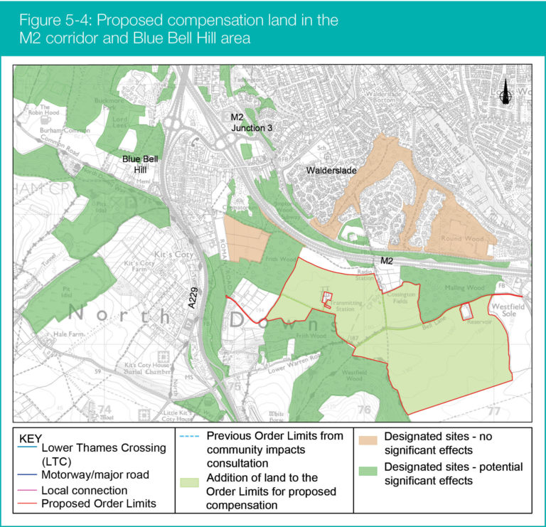
This site would be approx 104 hectares and is made up of what is currently farmland. This land is within the Kent Downs Area of Outstanding Natural Beauty (AONB).
The impact here would be due to the impacts from traffic coming from the M20 and cutting through to the M2/A2 to reach the LTC via Blue Bell Hill.
You may remember that back at the route options stage a route known as Option C Variant, that included improvements between the M20 and M2 along the Blue Bell Hill A229, was ruled out as not needed. Yet now it seems that the impact of LTC traffic in this area warrants nitrogen deposition mitigation or compensation, and also Kent County Council are progressing plans for Blue Bell Hill improvements separately as a direct result of the LTC and at a cost of around £142m. This has to again lead to more questions about whether more consideration needs to be given to the route selection, a process which we have always deemed to have been inadequate and biased.
Also notice on the map that shows the designated sites how on the southern side of the M2 the impacts are deemed significant, yet on the northern side a similar shaped site the same distance from the road is deemed not to be significantly impacted. There are other strange instances like this that we have noticed too, and just goes to show that the info shared is not adequate to properly explain things to us so that we can give considered meaningful responses. We would therefore recommend, as we always do, if any part of anything in the consultation or relating to the proposed LTC doesn’t make sense please comment about that fact in your response.
Gravesham and Shorne Woods (click the image below to enlarge)
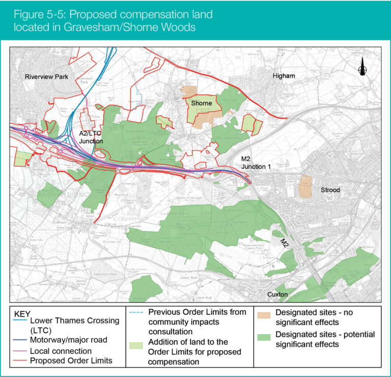
These sites total approx 55 hectares, and are again made up of what is currently farmland.
These parcels of land are in close proximity to Ancient Woodlands and Sites of Special Scientific Importance, as well as being nearby to other environmental mitigation land. NH say that this will help improve connectivity and enhance habitats.
Southfields – Thurrock (click the image below to enlarge)
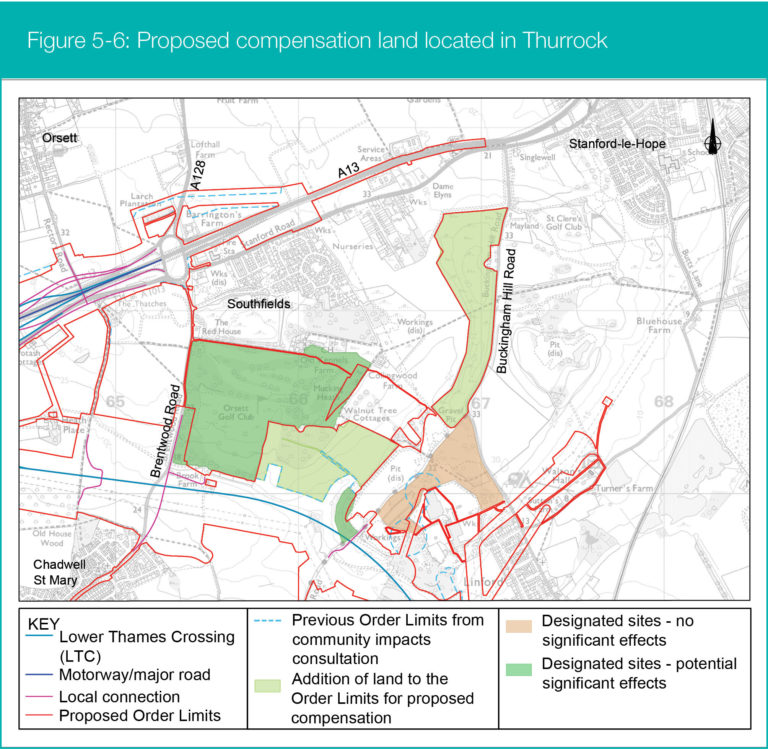
These two sites total approx 45 hectares.
The eastern site is publicly owned by Thurrock Council and is the landfill site behind the Linford Tip on Buckingham Hill Road.
After some local research it appears to us that this site is supposed to be landscaped as a condition of it being used as a landfill site. We therefore question why NH are proposing landscaping it as compensation land when it should be done anyway as a condition of the landfill use of the site.
They state that prior to any soil disturbance or vegetation removal, to prevent the potential disturbance of residual contamination appropriate risk assessments would be carried out for this site.
The western site is again farmland.
Hole Farm – Brentwood (click the image below to enlarge)
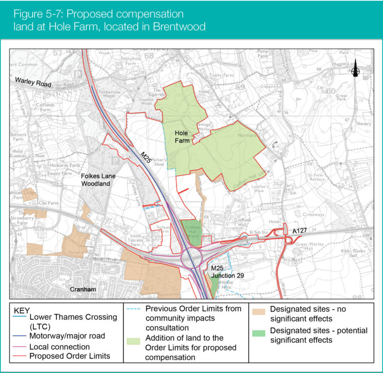
This site is one that leads to many many questions, because it is already highly controversial. Originally National Highways bought this site in 2021 to ‘improve biodiversity’ along their major routes, in this instance the M25 since that is the major route it sits alongside. However, they did also attempt to greenwash the LTC project by association with their plans for Hole Farm Community Woodland. But at the same time as trying to associate the community woodland project that was supposedly to improve biodiversity (even though they have not completed ecology surveys to know what the current level of biodiversity is), they were also stating that Hole Farm Community Woodland would go ahead regardless of whether the proposed LTC happened or not.
Yet now it seems that they are bringing the Hole Farm site into the LTC development boundary and project.
To add to the confusion and controversy, they still state that they will be applying to Brentwood County Council later this year for planning permission to change the use of the land from agricultural to woodland. They also plan to start planting trees there later this year subject to the permission being granted by Brentwood County Council. To be clear Brentwood County Council can obviously not grant permission for the LTC, only local planning, and works for the LTC cannot begin until such time as a Development Consent Order (DCO) is granted. It therefore has to be asked if NH who own the land already create a woodland and habitats on site for their community woodland biodiversity improvement plans, how can they also be claiming it as compensation land for the LTC project nitrogen deposition?
They were already going to be using a small part of the Hole Farm site for environmental mitigation for LTC, but are now proposing to add up to 75 hectares as compensation land. The whole site is as the name suggests farmland. We have emailed NH with many questions on this as the info is certainly not clear and informative as it should be, and things don’t sit well for us on this aspect.
We appreciate that this is a long update and this aspect of the proposed LTC is far from easy to understand, especially with the limited and confusing info that NH have provided. We hope our update helps, and we too are waiting on answers to the many questions we’ve submitted to NH. We will update further as and when we get any replies if the responses offer any answers/info. In the meantime we would highly recommend commenting as best you can in your response and if you find the info confusing say so in your response. Remember we have the right to comment on all aspects in our own words whether that be the actual project or inadequacies of the consultation!
Related
Nitrogen Deposition compensation changes update – click here