
Lower Thames Crossing maps (issued 14th July 2021)
Lower Thames Crossing maps (issued 14th July 2021) by Highways England as part of the Community Impacts Consultation documentation.
You can find their latest interactive map here.
2021 - Map book 2 - Land use plans
All Lower Thames Crossing maps (issued 14th July 2021) are available to view, and download on the Highways England Lower Thames Crossing consultation website:
Please note some of these files are large in size, worth noting if you are using data
- Map Book 1: General Arrangements 53.4 MB (PDF document)
- Map Book 2: Land Use Plans 36.5 MB (PDF document)
- Map Book 3: Engineering Plans 14.1 MB (PDF document)
- Large scale maps operation 41.6 MB (PDF document)
- Large scale maps construction 20.0 MB (PDF document)
- Large scale maps land use 34.0 MB (PDF document)
- Map books 1, 2 and 3 (combination of these documents in one PDF) 103.4 MB (PDF document)
- Aerial view of the proposed Lower Thames Crossing route 87.1 MB (PDF document)
When viewing some of the maps you will likely find it helpful to look on Google Maps or similar to help identify places on the the HE maps as the maps that they overlay their plans on are often not very detailed.
If you feel your property/land is directly impacted we would recommend contacting Highways England with any queries you have. We are not qualified legally, and share the info on this website as fellow concerned residents. We would always recommend seeking professional legal advice if needed.
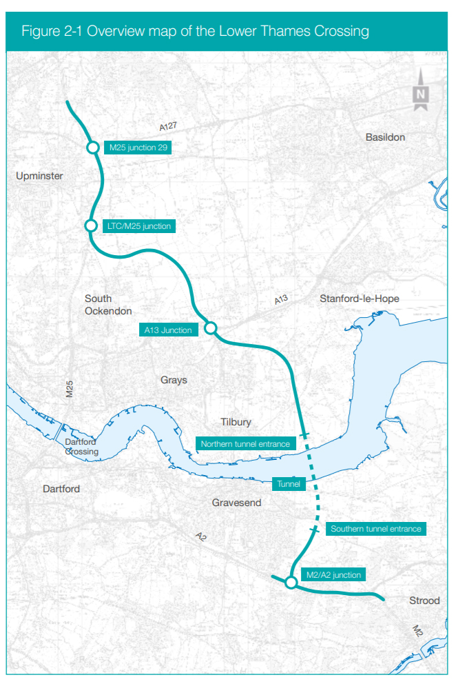
A quick overview
This is image shows the whole route which is helpful to get a quick overall view of where the LTC route is proposed to go. This purely represents the proposed route of the actual road, and not the development boundary.
Previous maps issued
In case you need to view any of the now historic/archived maps of the LTC route please see the following:
LTC maps as issued on 14th July 2020 – click here | Related – LTC map legends issued (July 2020) – click here
LTC maps as issued on 29th January 2020 – click here
LTC maps as issued on 10th October 2018 – click here
LTC maps as issued July 2018 – click here
LTC maps as issued Nov 1st 2017 – click here
LTC route 2,3,4 maps 2017 – click here