
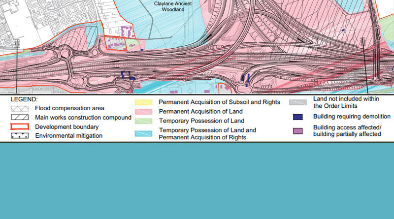
LTC Map Legends (issued 2020)
There have been many questions and concerns over what the LTC Map Legends actually mean. The wording of the descriptions has changed since the new maps for the Supplementary Consultation launched on 29th Jan 2020.
We asked HE to provide us with further clarification as to what the LTC Map Legends mean, this is what we have been told.
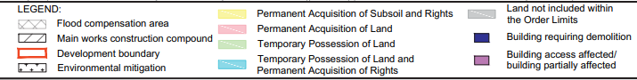
Flood compensation area – potential areas where we may need to lower the level of the existing land to replace flood zone that will be affected.
Main works construction compound – self-explanatory
Development boundary – self-explanatory
Environmental mitigation – to help mitigate the impacts of the proposed road. This could include replanting areas of woodland or creating new wildlife habitats.
Permanent Acquisition of Subsoil and Rights (yellow) – permanently acquiring subsoil for the tunnels themselves and rights to restrict uses above them for protection of the tunnels.
Permanent Acquisition of Land (pink) – self-explanatory
Temporary Possession of land (green) – for construction
Temporary Possession of Land and Permanent Acquisition of Rights (Blue) – for the construction and installation of utilities such as overhead electricity pylons and gas pipelines and permanent rights or easements to operate and maintain them. Some blue areas (with crosses) are also for ecological mitigation, such as the erection of bat boxes, where we will need access to certain areas to install mitigation and require rights to maintain them.
Land not included within the Order Limits (grey) Areas that are shown as grey are ‘island’ areas that are surrounded by development boundary. These are shown as grey rather than white to make it clear which areas of land are inside and outside the boundary. On some of the sheets of Land Use plans that are particularly complex it can be difficult to interpret ‘island’ areas as they are sometimes shown over two or three different sheets. The grey areas help to illustrate this.
Building requiring demolition (purple) – self-explanatory
Building access affected/building partially affected (dark pink) – self-explanatory
We have been told that the wording has changed on the legend explanations on the land use plans to conform to how the areas are likely to be labelled on the plans submitted as part of the DCO application.
LTC Maps issued Jan 29th 2020
A list of all LTC related maps that were released on 29th Jan 2020 as part of the Supplementary Consultation can be found on our website – www.thamescrossingactiongroup.com/lower-thames-crossing-maps-issued-29th-january-2020/ and also the official HE/LTC website – https://highwaysengland.citizenspace.com/ltc/consultation-2020/ (scroll towards the bottom of the page).
Hopefully with the further clarification from HE of what the LTC Map Legend descriptions mean it may make it a little easier to now understand the maps!
Why is does it have to be so confusing?
If you have any specific queries relating to the maps, legends, or indeed anything else relating to LTC please don’t forget that you can call HE on 0300 123 5000 or email info@lowerthamescrossing.co.uk. Please be aware that it can take up to 14 days to get replies. HE also have a number of info events starting on 21st Feb (full list of events can be found here), where you will also be able to ask questions.
If you are or have had any difficulty understanding any of the consultation info/docs/maps please do express your concerns when you respond to the consultation. HE have an obligation to ensure that people have been provided with adequate info, and they will not want the Planning Inspectorate hearing people do not feel they have had adequate info during the DCO Examination! Please voice any concerns in your consultation responses!