
Lower Thames Crossing maps (issued 14th July 2020)
Lower Thames Crossing maps (issued 14th July 2020) by Highways England as part of the Design Refinement Consultation documentation.
HE have included an interactive map option on the virtual exhibition – https://arcg.is/0LSu4L to help you locate yourself in relation to the proposals.
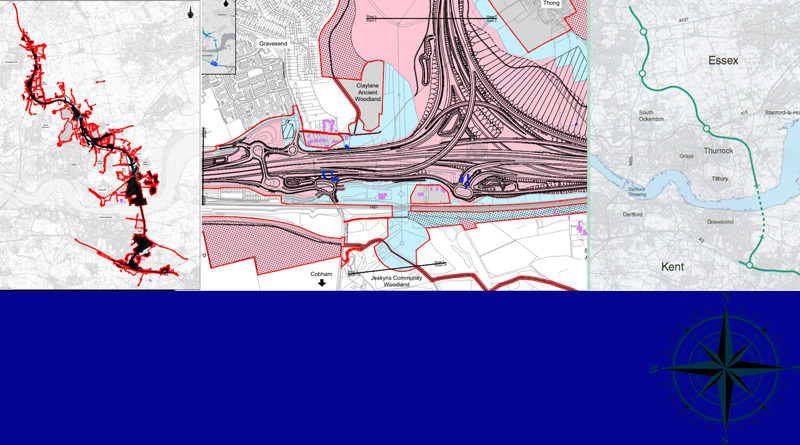
One of the map books we find ourselves referring to most during consultation is Map Book 2 – Land Use Plans so we’ve embedded it below for you. Click the arrows to move through the pages and click + and – to zoom in and out. If you want to view it larger and/or download it the link is further down this page in the main list of all the available maps.
Please bear in mind that north changes orientation in these map books, so keep an eye on the compass to see which angle you are viewing from on each page, it can get confusing very quickly sometimes!
Oh and watch out for incorrectly spelt and incorrectly labelled places on maps we’ve noticed a few already which will include in another update being published soon!
LTC Design Consultation 2020 Map Book 2 land use plans
The other map we seem to be using more and more with these later changes is Map Book 1 which is top of the list below.
Please bear in mind these map books all have their own map legends which need to be read to better understand the maps. Some of the map books, such as Map Book 3, are more complicated than others to read and understand as they are not straight forward, you need to know how to read engineering plans otherwise you can easily get confused. If you are unsure about what you are viewing, especially with Map Book 3 it is always best to seek advice.
All Lower Thames Crossing maps (issued 14th July 2020) are available to view, and download on the Highways England Lower Thames Crossing website:
- LTC Design Consultation 2020 Map Book 1 General Arrangements 27.7 MB (PDF document)
- LTC Design Consultation 2020 Map Book 2 land use plans 37.2 MB (PDF document)
- LTC Design Consultation 2020 Map Book 3 engineering plans 6.0 MB (PDF document)
- LTC Design consultation 2020 Large scale General Arrangement maps 63.6 MB (PDF document)
- LTC Design Consultation 2020 Large scale land use maps 11.3 MB (PDF document)
- LTC Design Consultation 2020 whole route General Arrangements 19.6 MB (PDF document)
- LTC Design Consultation 2020 whole route land use plan 19.2 MB (PDF document)
- LTC Design Consultation 2020 Aerial view of the proposed LTC route 63.2 MB (PDF document)
- LTC Design Consultation 2020 Environmental constraints map 7.1 MB (PDF document)
When viewing some of the maps you will likely find it helpful to look on Google Maps or similar to help identify places on the the HE maps as the maps that they overlay their plans on are often not very detailed.
If you feel your property/land is directly impacted we would recommend contacting Highways England with any queries you have. We are not qualified legally, and share the info on this website as fellow concerned residents. We would always recommend seeking professional legal advice if needed.
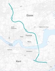
A quick overview
This is image shows the whole route which is helpful to get a quick overall view of where the LTC route is proposed to go. This purely represents the proposed route of the actual road, and not the development boundary.
Previous map issues
In case you need to view any of the now historic/archived maps of the LTC route please see the following:
LTC maps as issued on 29th January 2020 – www.thamescrossingactiongroup.com/lower-thames-crossing-maps-issued-29th-january-2020/
LTC maps as issued on 10th October 2018 – www.thamescrossingactiongroup.com/lower-thames-crossing-maps-issued-10th-oct-2018/
LTC maps as issued July 2018 – www.thamescrossingactiongroup.com/updated-red-line-boundaries-july-2018/
LTC maps as issued Nov 1st 2017 – www.thamescrossingactiongroup.com/updated-red-line-maps-1st-nov-2017/
LTC route 2,3,4 maps 2017 – www.thamescrossingactiongroup.com/historical-maps/