
Yet more LTC updates
Another of our updates on our latest discoveries regarding the proposed Lower Thames Crossing and it’s impacts on us all.
Electric Vehicles
Highways England keep on telling everyone how we won’t need to worry by the time LTC opens (if it opens) as there will be so many electric vehicles on the roads.
We recently came across this interesting article by the Institute of the Motor Industry – www.fenews.co.uk/press-releases/22479-only-3-of-all-vehicle-technicians-are-currently-qualified-to-work-on-electric-vehicles The article states that only 3% of all vehicle technicians are currently qualified to work safely on electrified vehicles – the vast majority of whom work in manufacturers’ franchised dealerships.
Also not to forget that even if there are as many electric vehicles on the LTC as HE suggest, where will all the electric come from. We don’t suppose it will all be clean green electricity either, and we all know the impacts of power stations in our area.
This may be something you wish to consider commenting on when you complete your consultation response form!
Sat Nav Tracking
Someone questioned whether Highways England have/are using Sat Nav tracking data as part of their traffic modelling. You know using the anonymous data that is tracked by the satellites that the Sat Navs use to track where traffic is going.
Highways England’s explanation was that they are not using it to track destinations/journeys, but it may be used as validation tool, to validate the data they are using.
Spoil use at Bluelake in Kent
There have been comments on social media about the possible use of spoil from the LTC being used at Bluelake in Kent. Evidently, there was a Gravesham Borough Council presentation based on Highways England info. When we quizzed HE about this they said it was a possibility, but not definite. They say that there are many uses that could benefit local authorities etc by providing them with spoil for various projects, and these options are still to be considered.
Spoil contamination concerns
Many of us have concerns over the potential contamination of soil/spoil from the LTC, if it goes ahead. For instance we are aware that there are areas in the East Tilbury/Tilbury area that have been used for landfill for over 100 years with no records of exactly what has been tipped.
A gas pipeline that was planned a few years ago in the area was aborted due to tests revealing nasties in the ground.
HE’s response:
“Before any excavation will start, Ground Investigation will be undertaken to gather all of the available information on the area including obtaining soil and groundwater samples for laboratory testing for contamination. Initially a desk-top study will be completed followed by a comprehensive programme of site investigation to thoroughly assess the ground conditions and determine any risks. Any risks or hazards identified will then be taken in account in the planning and execution of the works. The UK Construction Industry has extensive legislation, process and procedures for the safe and successful development of historic industrial brownfield sites. A range of techniques can and will be used depending on the nature of the risks identified to ensure the safety of the surrounding community and workforce.”
and
“As part of an extensive desktop study, historic records have been obtained that do detail much of the historic waste disposal at the various locations to the east of the Northern portal area and HE are in direct communication with the current landowners in the area to help investigate the previous land uses and history. The existing records are being evaluated ahead of any future additional studies and design decisions.”
HE say they research and test accordingly, following guidelines. However, surely we want and deserve better reassurances. We know that they won’t find records for some of these landfills with unknown waste. Exactly how do they test the ground to assess if it is safe without disturbing the possible contaminates and toxins that could easily be released into the air when they break the soil to test? Definitely something to express concerns over in your consultation response.
Doormouse boxes in Great Crabbers Wood, Shorne
Someone else questioned why 40 doormouse boxes were put up by Highways England in Spring 2018 at Great Crabbers Wood, Shorne. Highways England, were unable to comment when we asked them at an info event, and suggested we email in for an answer. We have submitted the question via email, and to date are still waiting a response.
Relocation of electricity pylons
We asked HE if the relocation of electricity pylons would be taken into account in the Health and Environmental Reports. They have told us they will be. This is obviously very important, especially for those residents who will endure electricity pylons much closer to their homes if LTC goes ahead, due to the EMFs and noise pollution. Have you heard the hum/buzz coming off those things, especially when it is wet, it’s awful.
Mitigation Trees
Some have been asking how long the trees that HE place as part of the mitigation can be expected to stay. We have had conflicting info from HE on this. At one info event we were told by an environmental expert that trees would be guaranteed to be part of the plan and there for mitigation for at least 15 years. However, Tim Jones (LTC Project Director) has also since said that there are no guarantees and that it will be up to the land owner of any land that is used for environmental mitigation.
We emailed to ask HE to clarify, this is their response:
“The documents provided as part of our consultation provide an initial view on the measures that will be required to mitigate the effects of the project. These are being developed further through the ongoing design of the project, and through this process we will consider feedback from the consultation, as well as the findings of ongoing surveys. We will also continue to consult with statutory bodies on our approach, including how the mitigation will be delivered and maintained.
Mitigation that is included in our DCO Application and the Environmental Statement will become a legal requirement of the Development Consent Order, so Highways England will be committed to delivering these measures as part of the project. Long-term maintenance requirements (including duration) will be defined as part of this process, and will be appropriate to the type of mitigation and its purpose. Maintenance requirements will be built into the contract for any organisation appointed to construct and operate the project.
Where mitigation is provided off-site through landowner or third party agreement, the mitigation to be delivered and long-term maintenance requirements will be defined as part of the legal agreement between Highways England and the landowner or third party and secured through the Development Consent Order that we will be seeking. Requirements will be appropriate to the type of planting and its purpose, and restrictive covenants may be considered if required.
If, in the future, there are proposals for redevelopment of land that has been used for essential mitigation, it would be for the appropriate consenting body to determine the application for that redevelopment, taking into account the requirements of preceding developments such as LTC. That development would therefore be required to provide appropriate measures to deliver the same objectives (be it screening or replacement habitat for biodiversity).”
We also question who will look after any trees and indeed other landscaping that HE put in place as part of mitigation. We have also been made aware by very knowledgeable locals in the Thurrock area that not many trees grow in places like East Tilbury. Take a look next time you are down towards the river, look across the land down there, not many trees, and evidently none of the farmers etc have been chopping them all down over the years, it is just not an area that trees naturally take to.
Potholes
It may be worth asking what impact the lack of proper maintenance of Highways England’s roads has on the issues we all suffer at the Dartford Crossing. We are all aware of the potholes and bad road surfaces, the damage it does to our cars, potentially causing accidents, and definitely causing delays when they have to do emergency repairs. Why are they not maintaining them to an acceptable level, and what confidence does this give us that they are not purposely creating traffic issues to warrant LTC, and also how capable they are to be managing and maintaining our roads at all, let alone be tasked with designing and creating new roads and crossings.
Roadside rubbish and parking
Yes, it is down to each and everyone of us to take responsibility for our own actions and not to litter, or if we’re lorry drivers not to park up in unauthorised areas. However, take a look at a road like the A1089 (a trunk road in and out of Tilbury, Essex). This road is a Highways England road, they are responsible for it.
How much litter do we see along this road? We know of one litter picking group who ran out of black bin bags along there before they ran out of rubbish. They also found food packaging that had use by dates on it that were literally years out of date. Will HE do a better job in future, or on the proposed LTC and connecting roads?
If you drive along the A1089 you will also see either HGVs parked up on the verges, or the churned up mud on the verges where the HGVs have been parked. This is not on, it’s not safe, and the mud that is spread on to the road as HGVs park up and leave causes a hazard on the road. Again, shouldn’t we expect better from HE in their management of our roads?
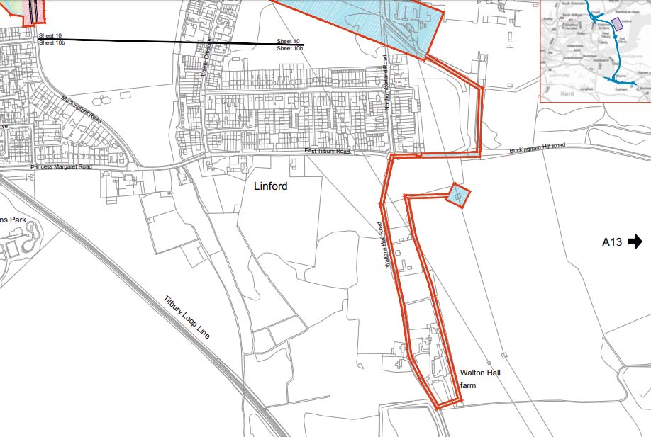
Strange utility use land take area near Linford
We noticed that strange straggly shape on the map that is shaded for utilities use. We asked HE about it, and the reason for the long straggly shape is for access to a pylon that is needed by the National Grid.
Offline road impacts and detours
As we know many of our existing local roads will be impacted due to realignment and changes in places to accommodate the LTC if it goes ahead.
Some like North Road in South Ockendon will have to be worked on to put a bridge in that will go over the LTC. HE has advised us with work like this they will create the new road/bridge offline. This means that they will construct as much of it as possible to the side of the existing road, only when it is as ready as possible will they close North Road for the shortest time possible to make the connections between the new part of the road with the existing road.
However, Ockendon Road in Upminster will need two adjustments. and the part that joins to the railway bridge section will not be able to be worked offline as they call it. This means they will need to close access on the road, as this is how they work in situations like this where there is a railway line to take into account.
What will the impact be to residents that live in places like Bridge Cottages? Where will drivers and buses have to divert, remembering that this is the route many take to get to the Crematorium too.
HE also have concerns that Brewers Road south of the river could be problematic for them.
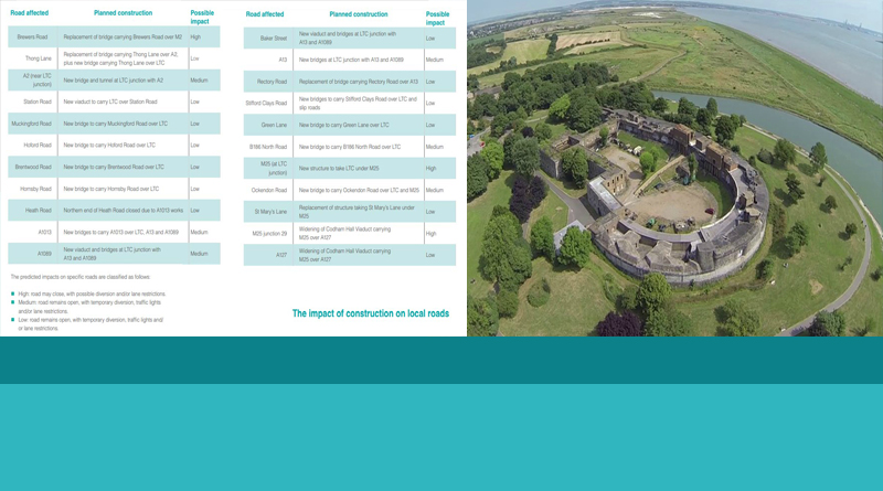
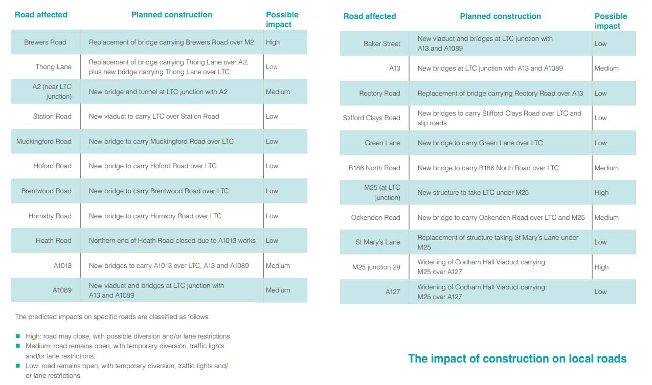
You can read more about the impact of construction on local roads on pages 114 and 115 in the Consultation Guide, which rates the expected impact it will have on local roads both north and south of the river.
Plantroom/control building in East Tilbury
When you look at the maps, HE show a control building to the south of the LTC tunnel portal in East Tilbury. We asked HE what this building will look like, size etc. They said it was still to be decided. We were told there is a chance it could be concealed within the portal design. This may be something you want to comment on in your consultation response.
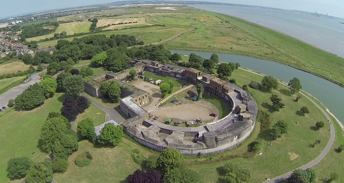
Impacts on Coalhouse and Tilbury Fort
You have to question how much irreversible damage LTC will do to Thurrock (and indeed all areas that LTC passes) when you have historical registered buildings like Coalhouse and Tilbury Forts within a mile or so of a proposed new 6 lane motorway.
Coalhouse Fort has recently been awarded £47k from the Government’s Coastal Revival Fund – www.thurrock.gov.uk/news/coalhouse-fort-park/coalhouse-fort-boosted-with-%C2%A347000-from-governments-coastal-revival-fund. Anyone who has walked the 2 Forts Walk will have great concerns over LTC ripping through with the air, noise, and light pollution. Plus indeed any vibration pollution/impacts that could be had all along the route, including so close to the historic fort.
Love Lane, East Tilbury
Whilst talking to HE it has also been hinted at that the Love Lane access to the service station might need to be looked at to improve access for pedestrians from the station, for workers at the service station etc. To be clear this has not been included in the LTC designs, but this was mentioned to us as a possibility that could need considering moving forward. Again think of the impacts this could have.
Construction Carbon release
We quizzed HE on the carbon release during construction. Their response was that construction companies these days know of the need to take things like carbon release into account. Energy efficient machines, hybrid equipment, using the plant on site were all mentioned as things that would be taken into account.
HE also stated that the Code of Practice would also cover this, which would become available at the time of their DCO application.
It has also been recently bought to our attention that London have announced new standards for construction vehicles in London, we should demand that we get the same standards if LTC goes ahead.
A1089 magical portal
HE keep telling us that due to what they consider a lower level of traffic movements southbound on the A1089 they have not added a A1089 southbound direct connection from the LTC. You know this is the one where on a daily basis traffic coming off LTC wanting to go south on the A1089 will have to detour all the way eastbound on the A13 to the Stanford junction, up and around the roundabout and back on itself westbound to the A1089/LYC joint slip road, to get access to the A1089 south.
What confuses us is why did HE consider there was enough traffic to warrant putting an A1089 northbound direct connection to the LTC in the first place. How on earth does the traffic get to the south end of the A1089 to take these journeys northbound without first having to go southbound on the A1089? Are HE planning on putting a magic portal at the bottom (south end) of the A1089 to allow them to get there without using the A1089 southbound to make all their journeys northbound on the A1089?! To date nobody at HE can explain this!
HE Property Team issues
Sadly we have been made aware of all sorts of issues from residents concerning letters from the HE property team.
We know that there has been much confusion over letters sent to mortgage providers, we covered this in a previous update. Indeed HE send letters to mortgage providers as they have a legal interest in the property, just as the resident does. This did cause much confusion and stress to many residents, especially some that were sent in error when they shouldn’t have been.
We are also aware that some residents feel like they have not been given enough info and support from HE with regards to letters they have received about the impacts to their properties. We have done all we can to try and speed things up in the process of HE giving these residents the necessary time and info.
There are residents who have received letters from HE in November telling them their properties are within the development boundary and that their properties are therefore needed for the project, even though when you look on the HE maps the properties are NOT in the development boundary. This has of course created extreme stress for those concerned, and is totally unacceptable behaviour and a huge error from HE.
We made HE aware of these letters and they acknowledged that as we pointed out the properties are not in the development boundary and should NOT have received these letters. They said they would send a follow up apology letter and asked us to let the residents know the letters would be on their way. The apology letters from HE outlining the error and explaining they are not actually in the development boundary and would not be needed for the scheme were received. However, at this point the letter was also sent to a property further down the street that is actually in the development boundary. This has been bought to HE’s attention again.
We know the impact these letters have on residents, their health and lives, and it is not acceptable. We are sadly aware of residents who are suicidal over this, have suffered heart problems or attacks, and other serious health impacts.
HE Info Team issues
We are aware that many have had issues of not receiving responses from HE within their own guidelines of replies within 15 working days. We even had an email apologising for the delay and telling us we would have a reply by the end of the following week, which didn’t arrive until half way through the next week.
This is something we bought to the attention of Tim Jones (LTC Project Director) at our meeting with him and Stephen Metcalfe MP on Sat 1st Dec. He asked us to email him copies of the outstanding emails/questions later that day, and said that he would ensure that at very least someone would get back to us by the end of business on Mon 3rd Dec to let us know when we could expect replies to the questions. We finally got an email on Thurs 6th Dec, and some of the questions didn’t even include a full answer to the questions we had asked.
We know we are not alone in this as many of you have told us of similar experiences when contacting HE via email, and this is not acceptable.
HE’s responses have been “We are aware that some correspondents did not receive responses sent out from our correspondence team. We would like to apologise for this, as to our knowledge these responses were sent, but not received. We have resent these responses to the correspondents” and also “We believe there may have been a technical error with either of our systems that prevented you from receiving this email“.
HE info event issues
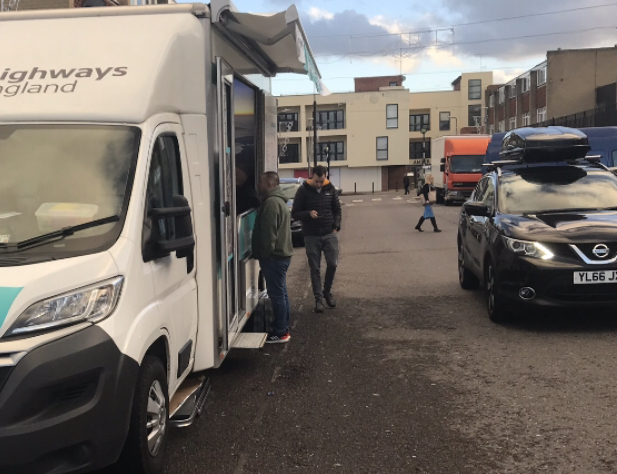
Obviously many of us have concerns over the HE info events and the fact that areas like East Tilbury didn’t even get a full info event, just a mobile van info event (which isn’t even part of the Statement of the Community Consultation (SoCC).
HE’s response as to whether they would consider a full info event in East Tilbury was:
“The locations and times of our consultation events were set out and consulted on in the SoCC. We looked at East Tilbury Hall as a venue however this was not deemed suitable on safety grounds. We held 8 events in Thurrock in Chadwell St Mary, Orsett, Lakeside (2 events), Linford, South Ockendon, Grays and Tilbury. These events were supplemented by our mobile information centre. While our event at Linford was busy, only a small number of people were asked to queue for up to 15 minutes during the busiest period. The event ran for 7 hours.”
Interesting they mentioned East Tilbury Hall as a venue not deemed suitable on safety grounds, as they told me that about the school, when I questioned why they were not using the School Hall in East Tilbury as TCAG had for our community event previously, which went very well. They seem to have had some confusion over which venue had the safety concerns. I was first told at an info event it was the school hall that didn’t pass their risk assessment as it didn’t allow adequate fire escape routes from the area HE staff would have used as their backstage/break area.
The mobile van info event in Corringham was questionable due to the health and safety issues of HE parking the van so that the access to the van was in the busy road, rather than on the kerbside. So it would seem HE take health and safety info account when it suits them.
We also question the knowledge of some of the HE staff at events, having witnessed some giving poor info or simply lacking the knowledge to answer questions. We even stepped in ourselves a few times to help members of the public out with info! This included giving out copies of the response form and envelopes to someone who hadn’t event been made aware of or offered response forms on the mobile info van.
Potential to move service station location
It has puzzled us all as to why the first we all learnt of the ‘need’ for a service station as part of LTC was only at statutory consultation stage, rather than any indication of it previously.
We are aware of three options that were considered by HE regarding the location for the service station. The three being either in Kent, East Tilbury, or South Ockendon.
- Kent was ruled out as the reason for a new service station is to reduce gaps between rest areas for safety as per Highways Agency guidelines, and it would be too close to the existing Medway services leaving too long for onward journey before next services at South Mimms.
- South Ockendon was ruled out over construction concerns of putting it on fenland.
- East Tilbury was the option they went for.
We have been told there is still a chance that an alternative location could be taken into account, dependent on consultation responses. However, someone who asked at an HE info event was also told that there is no room for change of location due to the Environmental Agency’s concerns over having fuel tanks (for the petrol station) located on flood plain.
We emailed HE, and this is their response:
“Rest and Service Areas (RaSA) perform an important road safety function by allowing road users to stop and take a break during their journey. The locations of the nearest services on the M2, M20, M25 and M11 mean that a service area should be provided along the route of the Lower Thames Crossing.
Distances with no RASA on LTC
| M2 Farthing Corner | M25 South Mimms | M20 Maidstone | M11 Birchanger | |
| M2 Farthing Corner | 56 | 55 | ||
| M25 South Mimms | 56 | 64 | 32 | |
| M20 Maidstone
|
64 | 62 | ||
| M11 Birchanger
|
55 | 62 |
Distances with RASA at Tilbury Junction
| M2 Farthing Corner | M25 South Mimms | M20 Maidstone | M11 Birchanger | |
| LTC RASA Tilbury
|
23 | 39 | 20 | 37 |
No element of the Lower Thames Crossing design is fixed. We will respond to the feedback we receive through our consultation as part of our Development Consent Order application. Our consultation is a vital part of the development of our plans and is an important opportunity for stakeholders and communities to shape the Lower Thames Crossing.
We considered potential locations along the length of the route, including upgrading the existing facilities on the A2. We discounted this because the distance to the next services (South Mimms) was substantially further than the distance to the services on A2. Also, there were no obvious sites available on the A2 near the Project that avoid the ancient woodland and Sites of special scientific interests.
We also considered locating the Rest and Service Area (RaSA) near Ockendon. We discounted this because the Project is on a viaduct at this location and it would be difficult and expensive to provide an access roundabout.
Within the vicinity of the Tilbury junction, we assessed locations to the south west, south east and north east. We chose the north-eastern site because it is outside the flood zone, avoids the historic landfills, other poor ground conditions and ground water protection zones, which would be affected by the other two sites. The site is also the furthest away from the scheduled monuments of Tilbury and Coalhouse Forts.
The design of the Lower Thames Crossing has continued to evolve since the Government announced its preferred route in April 2017. In November 2017, we set out a number of changes to the design and we updated the design again for our statutory consultation. The changes are set out in our Guide to Consultation. The inclusion of a rest and service area was part of the design changes we set out in October 2018 at the time of the start of our statutory consultation.
Regarding access, the details of the access to and from the staff and depot car parks have not been finalised however, emergency services access arrangements will be agreed with the emergency services through our regular forum.”
Noise sensitive areas
Someone shared the email they got from HE telling them that the LTC route had been changed to increase the distance to sensitive area, with regards to noise pollution. No further info was provided by HE, we tried quizzing HE at an info event on this to find out what change was made on the route and where. We were asked to email our question in, which we have done, and to date no reply.
We also had someone else share the following info that they got as a response from HE with regards to Noise Pollution:
“The 26 noise important areas referred to in the Guide to Consultation can be found in the Preliminary Environment Information Report Figures – Chapter 13 Noise and Vibrations here. The Noise Important Areas are indicated by the green shaded areas in the figures.”
Let’s also not forget as well as the construction and general noise pollution LTC would inflict upon everyone, some in our communities such as blind people who can tend to rely upon their sense of hearing more than others will be impacted greatly.
Charges for using the LTC
Lots of people have been asking about the charging costs for using the LTC. HE’s go to response on this is that it is all to be decided yet. So whilst we do know it will be chargeable, we don’t know how much, when the charges will be effective (eg will it be free like Dartford Crossing at night), or if residents will get discount, and whether we will need separate accounts to each crossing, or if they will be interchangeable.
Some details about the charges for the crossing can be viewed on pages 134 and 135 in the Consultation Guide. HE want our comments on this as part of our consultation responses.
Whilst reviewing info online regarding tolls and crossing charges we also came across this:
“Tolls are traditionally used to maintain the roadways where they are collected, and also to repay loans taken out to build said roadways. This is because toll roads generally utilize private money in cases where public money is not available or not forthcoming. In the classic case the money collected in tolls is then legally earmarked to repay these private investors and then what is left over is used to maintain the infrastructure and legally not allowed to be distributed anywhere else. Is some projects the roads are maintained before dividends are paid and in others it’s the reverse.
A taxed road is a different animal. In a taxed road scheme the government or local authority put up taxpayer funds to build the road. Then the “tax” collected goes to maintain the infrastructure. However unlike the toll scheme the government or local authority can then divert excess funds to any other function they need.”
This is not a direct statement with regards to the Dartford Crossing or LTC, but someone’s explanation of the difference between tolls and crossing charges. If this info is correct it would seem that technically a toll might be better as at least they are not legally allowed to distribute the income from the tolls anywhere else, it is invested in maintaining the infrastructure. If we have to suffer paying to cross at least the money should be put back into keeping the crossing maintained and working. Obviously free crossings are preferred!
Agricultural Land
We all know that there is a huge impact on agricultural land if the LTC goes ahead. Some of that land is Grade 1 listed, of which there is only 3% left in the country. Areas we are aware there is Grade 1 listed agricultural land is in South Ockendon, Chadwell St Mary, and Havering.
Our question to HE – Some of the arable land taken is grade 1, can you advise what spoil would be used to raise false cutting or for modelling in those areas?
Their response:
“HE Engineering team are carrying out an exercise to determine the type and amount of the various materials that will be made available through the construction of the scheme i.e. the amount of material generated from the areas of cutting’s and how much material is required to be used in the embankments. The principal intention will be to develop the design of the scheme to as far as possible achieve a cut/fill balance i.e. all material excavated can be reused within the highway alignment. If there is insufficient material available for embankments from within the scheme boundary then suitable material will be imported.
If excess material is generated or the material not suitable for reuse with the boundary of the scheme – i.e. for landscaping or false cutting – then this will be taken off site and recycled for beneficial reuse where ever possible. A desk study has been undertaken in relation to the quality of the agricultural land, and detailed Agricultural Land Classification (ALC) surveys will also be undertaken. This will provide the information needed to map the land grades across the scheme and to plan how soils will be handled and restored. This will be set out in a Soil Management Plan which will detail the restoration of subsoil and topsoil on the slopes created. It is envisaged that, in principle, the outer side of the false cuttings would have a gentle slope with the correct placement of subsoil and topsoil to enable the land to be returned to agricultural use where possible.”