
Revised utility proposals (East Tilbury)
National Highways have announced revised utility proposals in the East Tilbury area as part of the LTC Minor Refinements Consultation.
Three changes are being proposed:
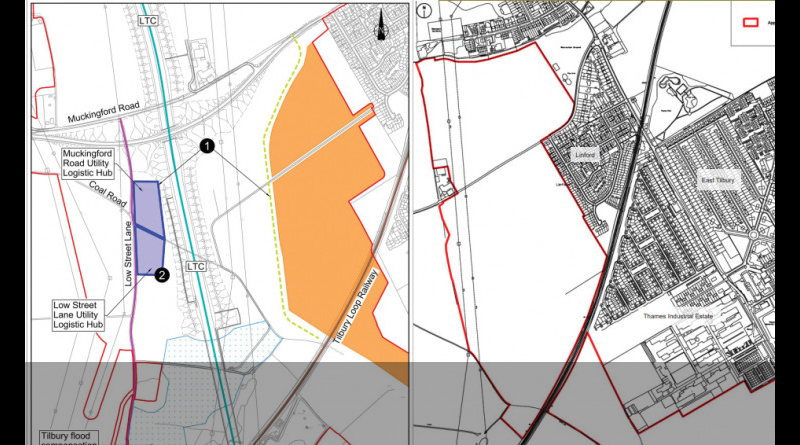
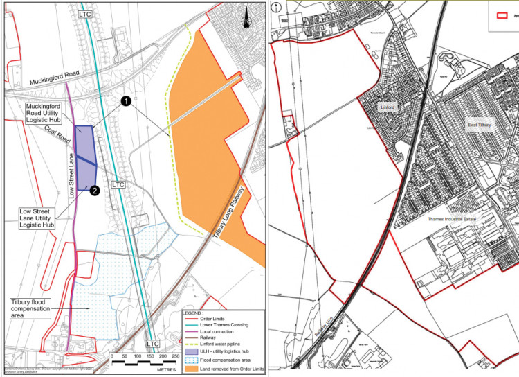
1 – Temporary Linford water pipeline
This temporary water pipeline would be to supply water to the tunnel boring machine during construction, if the proposed LTC goes ahead.
According to NH/LTC the proposed change would see approx 17 hectares of land removed from the LTC Order Limits (development boundary). As well as the temporary pipeline it would also see the Muckingford Road Utility Logistic Hub moved 250m west, which would see it located to the west of the proposed LTC route.
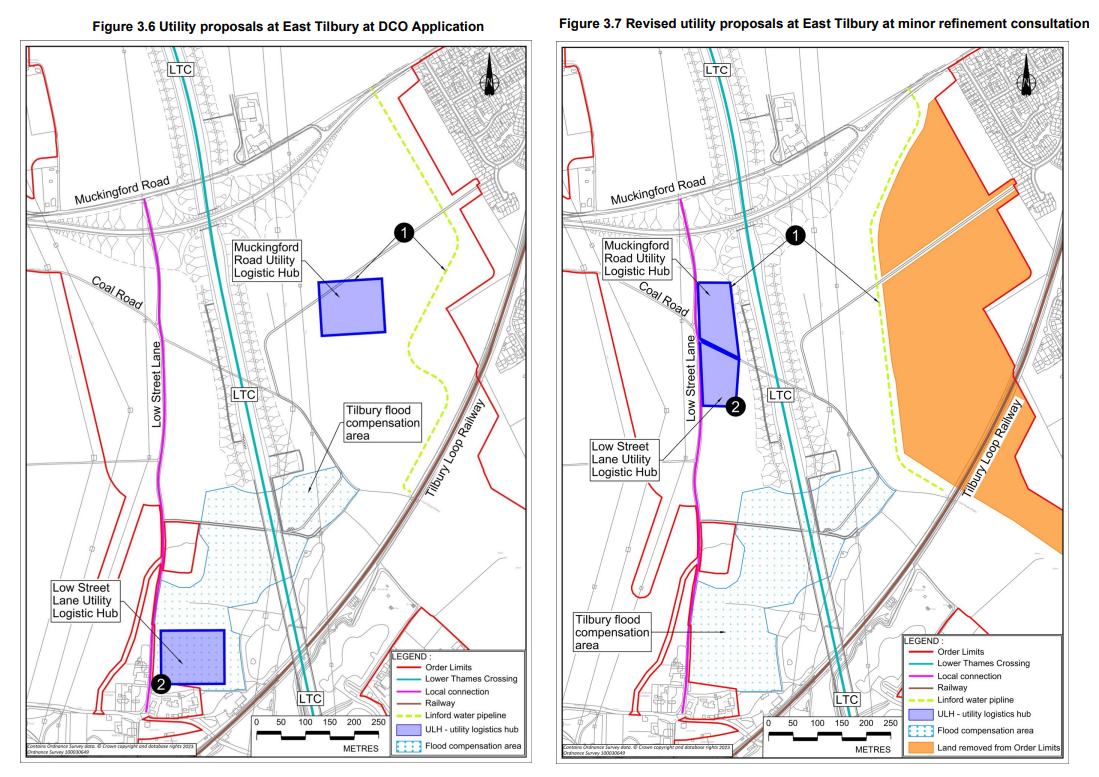
2 – Relocation of Low Street Lane Utility Logistic Hub
NH/LTC are also proposing moving the Low Street Lane Utility Logistic Hub approx 550m north than previously proposed, which will see this and the Muckingford Road Utility Logistic Hub sit side by side. The total area of both hubs together would be reduced from 2 hectares to 1.8 hectares. (The proposed location of the ULHs can be seen in the image above)
NH/LTC say that moving these two hubs to this new location will distance them from residents. However, it is also detailed that would be a temporary negative impact on soils in the area. as the land the hub would be moved to is a higher quality grade of farmland (grade 3a/grade 2 instead of grade 3b, as far as best and most versatile soil). More info on impacts to various grades of agricultural land in our update on LTC Impacts to Agriculture.
3 – Land Use Change (west of Linford)
According to NH/LTC the utility owner has requested a change to the land use for the proposed utility works to the west of Linford. Rather than land being needed temporarily, they are now requesting that it be temporary land use with permanent acquisition of rights.
So basically that means they would want to be able to have permanent rights to access the land for things like maintenance. Whey it has taken until now for them to realise and request this is beyond us, and is just one of many questions we have submitted to NH/LTC.
TCAG comment
Like many of you we found it difficult to get our heads around these changes, the whole consultation booklet just generates more questions than answers. However, something else that you may find of interest, if you aren’t already aware in regard to these proposed changes is that the land in question that would potentially be removed from the Order Limits is part of a planning application that’s in to Thurrock Council for up to 1000 homes.
The Planning Application 16/01232/OUT dates back to 2016, and had gone a bit quiet for a while, but reared it’s ugly head again more recently. The application documents detail how the development would be depending on whether the proposed LTC get permission or not.
TCAG responded to this planning application in March 2023.
To add another layer of intrigue, at an LTC Task Force meeting we were told by National Highways that they would be willing to construct a bridge to cross the railway line, to allow the much needed option to get in and out of East Tilbury when the barriers are down at the railway crossings.
As many sadly are aware being cut off, as East Tilbury is, can mean the matter of life or death sometimes. It shouldn’t be the case that residents and representatives in the area have to try and trade to get a safe route in and out of the area. Thurrock Council have previously said that only with more development as part of the future Local Plan as it is progressed, would come a new railway crossing bridge.
At the Task Force meeting NH/LTC promised they would build a bridge. They even went as far as to say they would do it sooner rather than later, and regardless of whether LTC goes ahead or not. Then it went very quiet, and became no longer an option.
Co-incidentally when the housing development project came back into action, the new bridge was pitched as part of the plans. We and others question whether this was added to act as a sweetener to try and garner support for such a large number of houses being built, if permission is granted.
But the application stated the amount of houses built would be dependent on whether LTC goes ahead or not, and then another layer of intrigue and strange co-incidence, NH/LTC remove a large chunk of the site proposed for the housing development in this latest Minor Refinements Consultation. All very strange.
Questions we put to NH/LTC on this change
Below are some questions we put to NH/LTC in regard to this proposed change after reading the consultation booklet, along with their responses:
Q1. If the temporary Linford water pipeline is for supplying the Tunnel Boring Machine(s), please can someone clarify how this would supply the TBM if only one TBM is used and turned around to come from the south to north? Or would a water source be needed south of the river, and if so from where?
“The supply from Linford would be for the TBM under both a 1 or 2 TBM methodology. The water would be piped from the northern portal compound to service both tunnel drives. No water would be sourced to supply the TBM from south of the river.”
Q2. Can someone please explain why the temporary water pipeline was proposed in a zigzag line prior to this proposed change? What was the reasoning of that configuration, and why is a similar configuration not needed now?
“The previous alignment was located between the proposed Tilbury Flood Compensation Area (FCA) – which has subsequently reduced in size, and existing utility networks. The pipeline is now located within the area that the FCA has vacated and is located further from receptors in East Tilbury.”
Q3. Why all of a sudden is the land that is proposed to be removed from the Order Limits not needed? What changed and why wasn’t the reason identified sooner?
“The Project continues to develop its design as a collaborative and iterative process, as explained in the Environmental Statement Chapter 2 – Project Description [APP-140]. Following stakeholder feedback and other design developments such as the reduction in the size of the FCA, the Project has reviewed its wider proposals, and following assessments of them, has determined it wishes to undertake these modifications to the application. This consultation was the first point at which these were developed sufficiently to consider and consult on them.”
Q4. Please can someone clarify what the light green line that passes through the orange (removed from Order Limits) area is? Why does it stop when it reaches the blue shaded area?
“The light green line is an existing footpath that would be re-surfaced as part of the Project.”
Q5. Is this proposed change to remove land from the Order Limits at the request of Iceni (or anyone else connected to the proposed housing development in the same area?
“The proposed change has not been made at the request of Iceni or any stakeholders connected to the proposed housing development. Refer to the reason for the change in Q3.”
Q6. Have NH/LTC assessed the impacts to the proposed housing development (on the shaded orange area)? If so please provide details. If not please explain why not. (Planning application 16/01232/OUT – https://regs.thurrock.gov.uk/online-applications/applicationDetails.do?activeTab=summary&keyVal=OD52TXQGH2J00)
“The proposed development is included within the Project’s Uncertainty Log – as set out in Table A.1 of 7.7 Combined Modelling and Appraisal Report – Appendix C – Transport Forecasting Package Annexes [APP-523]. This means the growth within the Project’s transport model has been spatially adjusted to include this proposed 1,000 residential development.
Output from the Project’s transport model is shown within the 7.9 Transport Assessment [APP-529] and data from the model is used by a number of environmental topics as set out within the 6.1 Environmental Statement.
The inter-project cumulative effects assessment presented in ES Chapter 16 Cumulative Effects Assessment [APP-154] did not include Planning application 16/01232/OUT as at the time of assessment the development did not fall within the temporal scope of the assessment. The age of the information available for the planning application indicated that the development was no longer being progressed. The amended information for the development was not submitted until after the DCO Application for the Project was submitted.
The proposed housing development was not included in ES Chapter 13’s [APP-151] assessment of development land because it does not benefit from an allocation or planning permission.”
Q7. Whatever happened in regard to NH/LTCs promise at an LTC Task Force meeting to build a bridge across the railway line near East Tilbury, regardless of whether LTC is granted permission or not?
“A bridge over the Tilbury Loop Line has never formed part of our DCO proposals, and we do not recall such a promise being made. However, we recognise this is a priority for local stakeholders and are in ongoing discussions with local stakeholders about how proposals could be brought forward and potential funding options.”
Q8. Why has it taken so long for NH/LTC to propose reducing the associated land take? What prompted this proposed change? Why has it only become a possibility since the DCO application was submitted?
“The potential reduction in Order Limits is associated with a review of the design and opportunities to reduce the temporary land required for construction. The timing does not relate to pre/post DCO application submission.“
Q9. Why has it taken this long to consider and propose locating the Utility Logistics Hub where it is now being proposed? Why was there previously a need to have two separate ULH rather than condensing them into one ULH?
“To clarify, there are still two ULH proposed. The ULH are co-located rather than combined.
The Project continues to develop its design as a collaborative and iterative process, as explained in the Environmental Statement Chapter 2 – Project Description [APP-140]. Following stakeholder feedback and other design and programme developments such as the reduction in the size of the FCA and when this FCA would need to be constructed, the Project has reviewed its wider proposals and determined that re-locating the ULH to its proposed location reduces the impact to the residents of Low Street Lane and permits the reduction of the combined sizes of the ULH’s, therefore impacting less land temporarily whilst ensuring the deliverability of the Project on time.”
Q10. Have the potential changes to groundwater effects mentioned in the ‘Road Drainage and the Water environment’ section on page 29 of the consultation booklet been assessed? If so please share details of the analysis and the proposed modifications to the REAC.
“As stated on Page 29 of the Consultation materials, the location of the realigned temporary Linford pipeline (Works No. MUT6) has the potential to change groundwater effects, however there are already Register of Environmental Actions and Commitments (REAC) mitigation measures to address similar potential impacts associated with utilities works in the same area. As such, as detailed in Page 29, the conclusion on significance already presented in the Environmental Statement remains the same and REAC item RDWE054 will be updated to include reference to Works No. MUT6 – please refer to the Code of Construction Practice, First Iteration of the Environmental Management Plan [APP-338]”
Q11. Please can you provide details of what the proposed layout and use of the proposed joint ULH would be?
“ULH 11 and 12 are two separate utility logistic hubs servicing utilities works associated with Work No. OH4. The proposed location is on either side of Coal Road, Tilbury, adjacent to Low Street Lane, Tilbury. Indicative ULH layouts are contained on Page 39 of 6.3 Environmental Statement – Appendix 2.1 – Construction Supporting Information Plate 1.19 Utility Logistics Hub alternative indicative layout – [APP-335].”
Q12. Please can someone explain why all of sudden there is a need to change the temporary possession of land mentioned in the proposed change west of Linford on pages 20/21 of the consultation booklet? Why didn’t the utility company previously request this change of land use? Why didn’t they need the temporary possession and the permanent acquisition of rights previously?
“The proposed change of land use relates to a single plot of land which has multiple utilities running through it (overhead power lines and the temporary Linford water pipeline). The land use change relates to the reconfiguration of utilities in this single land plot and the need to create permanent acquisition of rights to access, maintain and operate utility infrastructure as opposed to the previous temporary land use which related to land required for construction purposes.”
Make of the responses what you will!