
LTC and Benny the Beluga
Today at the HE info event at Lakeside Shopping Centre we quizzed HE experts on the Rest/Service Area, LTC/M25/A127 Junctions, Traffic Modelling data/info, and how the LTC might be impacted by wind and fog across the fens, plus why we love Benny the Beluga even more now! It’s quite a long one, so get ready!
Rest/Service Area
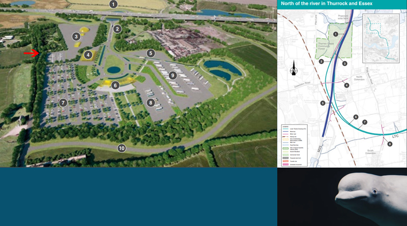
With regards to the rest/services area at the Tilbury junction. On the image below (taken from page 57 of the Consultation Guide) – the red arrow points to approximately where they are thinking of having an access road from the realigned Station Road. I was told they would expect this access road to be gated/have a barrier. Once through the gate/barrier you would be in the staff car park, for staff that work at the rest/service area.
One of the HE staff pointed out how they were trying to make it easier for local residents to get to work at the service area, as it would create jobs for locals and this access road would make it easier for them to get to work! I pointed out that this was the least of locals worries right now, and that air, light, noise pollution and the threat of service area traffic escaping on to the locals roads was more of a concern!
The area marked 3 on the image below is for the Maintenance depot, which again is likely to have another gate/barrier, as they will want it to be separated from the staff car park.
This would also be an access route for emergency vehicles in case of emergency. So through the gate/barrier off Station Rd, into the staff car park, through a gate/barrier to the Maintenance depot, and then into the Rest/Service Area.
I have to admit I did not ask if there would be another gate/barrier between the Maintenance depot and the Rest/Service Area. Also they did state that this is how it is likely to be, and we all know everything is subject to change.
They seemed particularly proud of the landscaping around the Rest/Service Area, which will be banked and trees. The lovely peaceful area of the pond bit across from the HGV parking (number 9 on the image below) I pointed out surely must be a safety issue?
Talking of HGV parking also led to me asking if they realised that many HGV would not be paying to park in their Rest/Service Area, and are more likely to try and park up on the road side around our local area, as they do now. To start with they said HGV’s would be on the LTC and there were no lay-bys for them to park in. I pointed out that traffic could and would still come off LTC and onto our local roads. After all they are encouraging HGVs to go along the A13 to Stanford down to Stanford junction, where HGVs regularly park on the Manor Way causing issues.
I explained out this was a big problem in our area, and not one we want more of, because some of these HGV drivers that park in lay-bys and on our roadsides are literally crapping up our area. (Please excuse my language, but I am sure you get the point of what I was saying to them!)
I also asked why if the Rest/Service Area is something they ‘have’ to put in rather than ‘want’ to put in this was the first we had heard of any Rest/Service Area on the LTC. I asked if it had anything to do with the services on the A2 being taken out by LTC. They said it wasn’t and stated that traffic joining the LTC would join before they reached the point where the A2 service station is (or would have been if not destroyed by LTC). They say that under DfT Circular Guidance there has to be a rest area every 28 miles. I have just Googled Dft Circular Guidance and managed to find this document for reference – https://assets.publishing.service.gov.uk/government/uploads/system/uploads/attachment_data/file/237412/dft-circular-strategic-road.pdf Page 14/15 seems to cover guidelines regarding this.
Sitting here writing this up, I am now starting my next list of questions that already includes:
- If the Rest/Service Area has to be every 28 miles, and is about safety, how fixed is the location of the LTC Rest/Service Area?
- If safety guidelines means a Rest/Service Area every 28 miles, what are the locations of the Rest/Service Area before and after the proposed LTC/Tilbury Rest/Service Area?
I imagine this guideline relates to new roads, but as a point of interest: On the M25 currently the distance between Thurrock to South Mimms Services is 34.2 miles according to Google Maps. South Mimms to Cobham Services is 44.7 miles. Cobham to Clacket Lane services is 34.4 miles. Clacket Lane to Thurrock Services is 30.9 miles. Orsett Cock via A128 onto A127 onto M25 to South Mimms is 36.1 miles (closest direct(ish) route I could think to get an idea of distance that could be similar to proposed Tilbury Services to South Mimms).
LTC/M25/A127 Junction(s)
After an email from someone in response to the latest newsletter questioning the A127 junction on the M25 (J29) I took a closer look at the maps and docs regarding this junction, along with the LTC and M25 junction.
Hope you’re sitting comfortably!!! Then I’ll begin…….
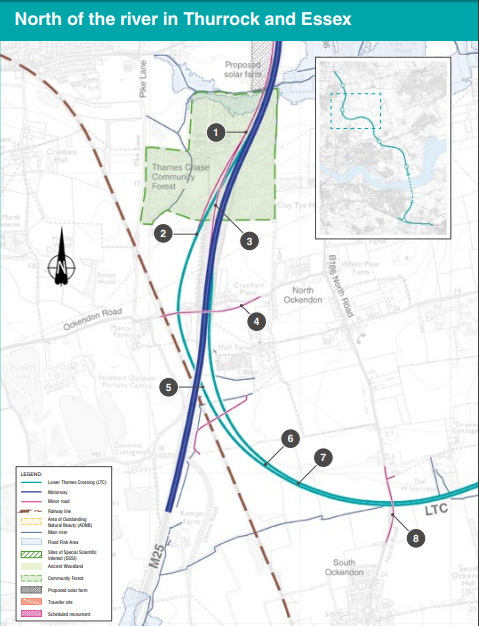
On the image below the M25 is shown in dark blue, the LTC in the lighter blue.
Looking from the bottom right of the image the LTC (lighter blue) is split, the fork off to the right is where the M25 traffic (south bound) has joined the LTC to head South bound towards the A2.
The (lighter blue) right fork is two lanes that go under the M25 (number 5 on the image) and bend round to merge with the M25 heading North bound.
Before it actually joins the M25 you will notice a pink line split off to the left of the light blue line (number 2 on the image), this is a single lane to a new parallel road (marked as number 1 on the image) that will run along the side of the M25 all the way up to the A127. The parallel road is one way with two lanes and a hard shoulder
The other pink line that comes off the M25 (number 3 on the image) is the two lanes slip road from the M25 to get to the A127. This will leave the M25, go over the LTC northbound joining M25 northbound slip road, and then connect with the LTC northbound to parallel road to A127 northbound. So this means 3 lanes merging into the 2 lane parallel road to the A127, with traffic from the LTC having merge into the two lanes that came off the M25.
The speed limit on the parallel road is planned to be 70mph, and looks to be just under 2 miles long, since they state that the LTC junction with the M25 will be located just under two miles (3km) south of M25 junction 29, bearing in mind that to access the A127 you have to leave at the LTC junction!
Don’t forget also that there’s the bottleneck on the M25 anti clockwise where it drops from 4 lanes to 3 lanes for a section of around 1.8 miles long. Just a reminder…
So the top of that section is around where the traffic from the LTC merges onto the M25 heading North anti clockwise. As the two LTC lanes come to join the M25 one will merge with M25 left lane, the second lane of the two lanes will actually create the fourth lane back to the M25. There will then be 4 lanes through and across where the M25 goes over the A127 roundabout. The exisiting J29 slip road that you would use if you wanted to leave the M25 anti clockwise for the A127 is removed, so your only exit off the M25 anti clockwise to the A127, is off onto the parallel road just before LTC traffic merges onto the M25, around 2 miles before the actual A127 roundabout!
Coming Southbound on the M25 clockwise there will be 4 lanes of traffic over the A127 roundabout. There will be two lanes of traffic on the slip road to the M25 Southbound from the A127. One will merge onto the M25, the other slightly longer will actually join creating a 5th lane on the M25 Southbound clockwise. This extra lane then becomes the slip road that goes off the M25 and turns straight into 3 lanes (around the point that the M25 goes under Ockendon Road) starting the LTC heading Southbound towards the A2.
I hope that makes some kind of sense, as it is a lot for us to get our heads around.
Traffic Modelling
Again I spoke to HE about their traffic modelling, this time a different expert, but the info seemed quite consistent. I really am trying to get my head around this black magic they call traffic modelling!
I know it is meant to be super complex and people study for years to learn all about it. However, we need to do our best to get to grips with it, because put simply their traffic modelling is nowhere near reflective of the traffic we live with on a daily basis.
I think the main point I have sussed is that they only use data that they consider to be average traffic. So if we have an incident on the M25 or at the Dartford Crossing which impacts traffic, they drop that data out of their traffic modelling, seeming to ignore the fact that for us this is average traffic these days sadly.
I tried to ask them since the original criteria for the project was to try and fix things at the Dartford Crossing, how could they simply ignore the data that represents those problems when trying to find a solution? I’m not sure their either liked or really got what I was getting at.
What I have managed to agree with them is they are going to try and find out if there is info available to send us that explains the criteria of what they consider to be worthy of removing from the traffic modelling data, and how often this happened.
I did also ask if they had ever tried running the traffic modelling based on data that hadn’t had the times they considered not to be average traffic removed. They couldn’t answer that either, so I asked them if they could find out for me. Let’s see what they come back to us with.
LTC Wind and fog across the Fens, and Benny the Beluga
Someone asked me about whether HE had taken into account the fact that the fens across from Orsett heading North along the route of the LTC suffer with some very strong wind conditions of around 70mph at times, and also the fog that is frequent and hangs around during Winter.
I asked one of the HE Environment experts today and was told that they are and would be looking into meteorological impacts as part of the Environmental report. She suggested that for high winds things like wind shielding and sections could be banked to offer protection from the wind to traffic.
Obviously fog cannot be treated in a similar way, and she suggested they would take into consideration things like the best lighting for foggy conditions, adequate road markings etc, basically doing what they can to the road to try and make it as safe as possible for drivers during foggy times.
I asked if they would likely just be using variable speed limits to reduce the speed limit at foggy times, and therefore slowing the traffic flow in an attempt to make it safer for drivers. She did start to refer to it as being a smart motorway, which I laughed at and said you might call it that I don’t see anything smart about it!
I also told her that I hoped they would be researching how much fog we get across the fens, how often, how long it hangs for etc, as to me it seemed like a daft idea to think about putting a motorway through an area with high winds and frequent fog in winter.
As I had the Environment expert I also ventured to ask if they were starting to consider what might happen if Benny the Beluga whale was still about, if they get permission to build LTC!! Well they are evidently cancelling fireworks displays down by the river because he is still about, and rightly so, we gotta look after him.
She seemed to think I was a little crazy at this point I think, and tried to tell me that she doubted he would still be about by then, and how ‘they’ (not HE but other experts) are meant to be looking into trying to lure him back down to the sea with whale song recordings. I said if he was happy and healthy that he was welcome to stay as long as he wanted, and that he may even invite his friends and family to join him! Again she did seem to be thinking I was just a tad crazy at this point!!
I moved on to ask her what was happening or would happen with regards to unexploded war bombs etc in the river, as we all know they show up from time to time round here. She said they are actually looking into that and had started scanning the river using some kind of technology similar to sonar kind of scanning of the river from a boat.
However, it seems that things have slowed down on that front since our dear friend Benny arrived!! How could we love that whale more right now?!! I told HE that we would be claiming Benny as our team/group mascot!! Then I pointed out that he had arrived perfectly around the time of the Consultation announcement, and was told they had actual recognised that fact. I mentioned to them I had tried to tell all the media that came down to the river that first day he was spotted, that he was there to object to the proposed LTC!!
Evidently the guy who first posted the sighting of Benny is one their environment team! So here’s to you Benny, we the thousands of members of TCAG love you and invite you to stay here as long as you are happy and healthy and want to!!