
Historical Maps
Highways England – Big Maps
These maps detail the Kent & Thurrock portions of the road schemes. They are rather large in file size, so please be patient when downloading!
Adjacent to the map links are key points to note. However, they do focus mainly on the Thurrock side of the Thames, as we are more familiar with the Geography. This shouldn’t detract the devastation these proposals bring to Kent – its just we have less understating.
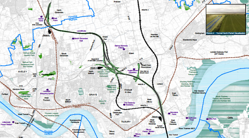
*Big Map – Route 2 – Isolates Tilbury from the rest of Thurrock. The road passes between Feenan Highway and the Gateway School. The new road then passes along Marshfoot Road to join the A1089, via a huge new junction.. It then passes up the A1089 on a wider road than current to a new junction at Baker Street (Orsett). Further Northwards across the fen’s to North Ockendon, where it joins with an extremely busy section of the M25 – Just south of J29.
*Big Map – Route 3 – Passes up between East & West Tilbury, Linford & Chadwell. Across Heath Place Farm. A huge new junction of viaducts will be located at Baker Street. While both Ports will navigate the Orsett Cock Roundabout to gain southbound access to the new road. Baker Street & Heath road look as though they could be prevented from joining the A1013. This route also continues further Northwards across the fen’s to North Ockendon, where it joins with an extremely busy section of the M25 – Just south of J29.
*Big Map – Route 4 – Passes up between East & West Tilbury and Linford parallel to Buckingham Hill Road till it hits the A13, South of Horndon on the Hill. We are not quite sure how this will effect the Orsett Business park, Sandown Road or the junction with the A1013 and Buckingham Hill Road. However, we do know Option C R4 proposed interchange at Horndon on the Hill is just as big, if not bigger than that of Baker Street. The road then continues North West between Orsett & Horndon on the Hill Villages, passing across farm and fen lands to West Horndon, where it joins with a new set of slipways onto and off from the A127 at The Halfway House, with its slipways clashing with homes towards the North end of Thorndon Avenue.
*Please note, these maps are hosted on the Highways England website for accuracy. If the links provided appear to be broken, please get in touch via email info@thamescrossingactiongroup.com
The following links provide detailed information for each of the routes. They show viaduct & slipway elevation (important for Tilbury / Little Thurrock, Orsett, Horndon on the Hill & West Horndon, Upminster, Cranham & North Ockendon).
Details of the bored tunnel and bridge are included. However, we have been told the Highways England preference here is a bored tunnel.
These documents detail where sections of the carriageway will be above & below existing ground level – Heath Place Farm (Orsett Heath), Tilbury Marshes, widening of the A1089, plus details of how the road will pass our farm & fen lands (the essential lungs of the Borough).
Scheme Assessment Report – Volume 3 Appendices Part 1 of 5 –
Scheme Assessment Report – Volume 3 Appendices Part 2 of 5
Scheme Assessment Report – Volume 3 Appendices Part 3 of 5