
LTC for walkers, cyclists, and horse riders
When it comes to the proposed LTC there are many issues for walkers, cyclists, and horse riders. There also appears to be a lot of misleading information from National Highways/LTC.
On 16th February 2022 National Highways/LTC released further info about the proposals for walkers, cyclists, and horse riders. The latest update includes new artist impressions, an illustrated map, and other path/route maps.
It was stated that there would be “over 60km of new or improved pathways for walkers, cyclist and horse riders, that will be delivered in Kent, Thurrock, Essex and Havering as part of the Lower Thames Crossing project“.
So to begin with 60km is just over 37 miles. 37 doesn’t sound anywhere near as much as 60 does it? Obviously both are the same distance, but it’s amazing how the choice of measurement denomination can make such a big difference in your head at first glance, especially when most of us think in miles rather than kilometres!
They go on to state “in total the Lower Thames Crossing will deliver almost 3km for every 1km of new road, designed to encourage active travel and promote health and wellbeing across the region“.
Firstly, we’d point out to NH/LTC that ‘will’ is a very presumptuous word to use, and that they don’t have permission for LTC yet!
We’d then move on to the fact that if they truly wanted to encourage active travel they would be proposing incorporating provision for active travel for crossing the river within the LTC plans. Yet instead they choose to push ahead with a proposal that only motorised vehicles that can use motorways would be able to use. And how they can suggest anything about promoting health and wellbeing when they are attempting to push ahead with such a hugely destructive and harmful road project is beyond us.
The information being shared doesn’t contain adequate labelling, there is no detail on how wide the paths would be, or what surfaces would be used, if any barriers and gateways would been included to avoid anti social access (ie motorbikes, quadbikes etc), and doesn’t even really make it clear who can use which paths as a whole picture.
We will be sharing feedback on our initial observations with NH/LTC, and will no doubt add to the list as we take more time to review the new information.
The illustrated map
In their update NH/LTC tell us what new journeys are available to us by looking at the new illustrated map, which can be viewed here.
To us this appears to be a complete fairy tale image on some imaginary land. The are trying to give the impression of lots of trees and wildlife, but how much would they be destroying with the proposed LTC? They show horse riders, but where will people be able to keep their horses in the area when so many stables, yards and fields for grazing would be destroyed by the proposed LTC?
Since when has Chadwell St Mary been to the west of the A1089? Or Orsett been to the north east of the Orsett Showground? How has the Mardyke ended up running so close to the Orsett Showground?
Are we really supposed to believe that we would be able to follow paths in line with the orange dots to all those destinations on safe pathways as suggested on this map? The reality as we see it from the more detailed maps is there would be no option to take a smooth uninterrupted path from say Orsett through the Mardyke Valley, to South Ockendon, up to Little Belhus Country Park and onwards north.
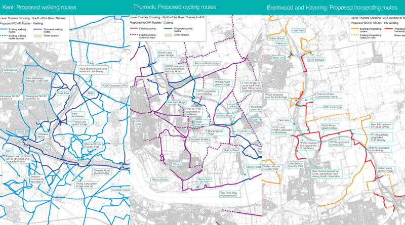
The path maps
Moving on to the supposedly more detailed maps. These maps are broken down into three categories of Walkers, Cyclists, Horse Riders. They are then broken down into three areas, Kent, Thurrock, Brentwood and Havering. However, in these area maps places like South Ockendon, which is definitely in Thurrock, are only shown on the Brentwood and Havering map.
The maps are supposed to show existing routes and proposed new routes for walkers, cyclists, and horse riders. However, we have noticed that on numerous occasions there are routes we know exist now, as we have used them, yet they are being listed as new proposed routes. We have to question whether National Highways have a box to tick in regard to ensuring their plans include x amount of new provision for walkers, cyclists, and horse riders and so are being creative with their detailing of these routes.
We all know that you can currently walk, cycle, or ride a horse along Rectory Road in Orsett, yet they are listing it is a new proposed route. Just because technically they will replace the Rectory Road bridge over the A13 with a much longer bridge to enable it to span the additional LTC junction slip roads, does not make the route new.
The same can be said of Baker Street, Orsett, just because they would need to realign it because of the LTC doesn’t mean they can list it as new. Nor the path that connects Baker Street to Mill Lane alongside the A13. And not the path alongside the old A13 (A1013) between the Orsett Cock all the way down to Blackshots area.
We all know that a section of the Two Forts Walk along the River Thames was damaged and the council closed it due to safety concerns. We all know it has yet to be repaired. However, Tilbury 2 pledged to invest in improvements for the Two Forts Walk as part of their mitigation, and now it seems NH/LTC are trying to claim the damaged section is a new proposed route.
We’re sure there will likely be more to add to this list, but these are the most obvious ones we spotted after an initial quick look.
Find out more about our theory on why the Thurrock walkers, cyclists, horse riders maps were replaced with different versions of those originally shared in our update here.
Why is their no provision for walkers, cyclists, horse riders actually on the proposed LTC?
According to NH/LTC when we have previously questioned them the proposed LTC connects motorway to motorway and whilst they call it an all-purpose trunk road, it would have restrictions that only those who can legally use a motorway would be able to use the LTC.
Because of this reason NH/LTC are not incorporating any Non Motorised Users to be able to use the actual LTC.
The Dartford Crossing has provision for cyclists to be able to call ahead and book a transfer for themselves and their bicycles to cross, as part of a free service for cyclists. Similar will not be available for the proposed LTC.
Let’s look at the theory that the LTC connects motorway to motorway. To the south of the river in Kent the LTC would technically connect to the A2. In Thurrock it connects to the A13. To the north you can exit the LTC via the proposed new parallel road onto the A127. It would therefore be possible to actually travel along the entire length of the proposed LTC without needing to use a motorway.
We can only assume that NH/LTC have to tick a box to say they are including plans for walkers, cyclists, horse riders into the LTC project, and so because they refuse to include provision into the actual LTC route, they are attempting to claim various other pathways surrounding the proposed route, including some which are actually existing routes already.
Update
Bearing the above in mind, about lack of provision and connectivity for active travel, we read with interest an article in June 2023 about the new National Audit Office report saying that Government is likely to miss its own targets for increasing rates of cycling and walking. LTC is a Government project so they should lead by example and support and encourage active travel.
Uncertainty for some walkers, cyclists, horse riders
Whilst mentioning the A127 area, it has been mentioned previously, and is still being questioned, as to the safety concerns that the proposed LTC would bring in for those trying to cross at the large M25 Junction 29 roundabout.
This is already a busy roundabout for people to cross, but there are crossing points. If the proposed LTC goes ahead it would see the addition to the new parallel road that connects between the LTC and the A127. It would add a free flow left turn, where traffic would not need to stop as it reaches the main roundabout as it would be in a filter lane. This widens the junction and appears would also remove the current crossing point. This ultimately means the route for NMUs to the south of the roundabout would be severed.
All the talk from NH/LTC that they are looking to improve connections for walkers, cyclists, and horse riders, mentions of new bridges on the A127, yet the reality is that the proposed LTC would sever links and increase risk for walkers, cyclists, and horse riders in situations like this, which is a busy route in the local area.
Impacts to walkers, cyclists horse riders during construction
What we already knew before this latest info is that during the construction period, if LTC goes ahead, there would most definitely be impacts to the Public Rights of Way. There would be obvious closures where footpaths, cycle routes, and bridleways are closed, as has been highlighted, all be it very badly, in the consultation materials.
Plus of course the loss of access to get out and enjoy our local areas and get our nature fix, which would have a negative impact on our health and wellbeing.
Questions on this topic that we put to NH/LTC in Feb 2022
We would again ask why NH/LTC are not making any provision for active travel in the actual LTC route and crossing?
We considered options during the development of the project to provide improved river crossings for walkers and cyclists. The options investigated include using the tunnel, upgrading the existing ferry, relocating the ferry, building a separate bridge or cable car, and providing a shuttle service through the tunnel. All of these options have been rejected for reasons including lack of technical feasibility, operational issues, lack of commercial viability, cost, environmental impacts and poor safety. Latent demand for walking and cycling across the River Thames at the project crossing point is low and therefore unlikely to unlock enough trips to make the required infrastructure for a shuttle service economically viable. In addition, journey times and distances for a shuttle would be excessive because the most suitable collection and drop-off points would be at the proposed M2/A2 junction and as far north as the proposed A13/A1089 junction.
At the southern end of the LTC it connects to the A2 (not motorway), it joins the A13 (not motorway), and the northern end can join to the A127 via the parallel road (again not motorway). Why no provision for cyclists to cross in a similar way to Dartford Crossing?
As above and below
Why is the proposed LTC restricted to vehicles that can use motorways? If it is being restricted to motorway vehicles then why is it being designated an APTR and not a motorway?
The project would be designed as an all-purpose trunk road with a restriction on heavy goods vehicles (HGVs) using lane three, similar to a motorway. There would be no other restrictions on HGV movements along the route. Although the route is not a motorway, similar restrictions would apply for safety reasons, so pedestrians, learner drivers, low-powered motorcycles, cyclists, horse riders and agricultural vehicles would be prohibited. These restrictions are due to the high volumes of high-speed traffic expected to use the route.
The decision to restrict certain types of vehicles has three key areas of consideration:
The standard (GD300) that LTC is designed in accordance with requires that ‘Walkers, cyclists, horse-riders (WCH) and slow-moving vehicles are prohibited’ for the design level (Level 3) of LTC. This is to enhance the safety and operational performance of the road.
To the south of the A13 the tunnel is a critical factor. Non-motorised and slow moving vehicles are prohibited from using the tunnel to achieve a consistent travel speed through the tunnels, reducing the likelihood of stoppages, overtaking manoeuvres and lane changing within the tunnel.
To the north of the A13 the majority of traffic joins to/from the M25. To achieve route consistency and to minimise the need complex signage, the same vehicle restrictions are proposed for this section of the carriageway.
We note that the info shared is again very limited and does not give detail such as how wide the pathways would be, what the surfaces would be. It is not clear who can use which routes and what provisions there would be for each type of user. Whether there would be gates, barriers etc.
We understand that many people are keen to know more detail such as what surfaces will be used, their precise widths and any accessibility issues. Should the project be granted permission to go ahead, these details will be developed by our main works contractors in partnership with the local authority and land owners. We do plan to share these details as soon as they have been developed.
All the horse riders shown on the map, where do NH/LTC think these people will be keeping their horses when the proposed LTC would destroy so many stables, yards, grazing fields?
We are working with affected landowners who own land used for keeping horses to mitigate impact and provide appropriate compensation.
How much of the pathways is truly new? How much are you claiming to be new when it is existing but just realigned or replaced?
We have been clear in our materials that the proposals include both new or improved paths, as they include improvements to existing paths, new sections of paths and new bridges.
33km of the 60km of the proposed new or improved routes are in Thurrock, and they have been designed to maintain existing connections as well as enable easier, safer and new journeys. Our plans include a new 3km cycle and footpath, segregated from road traffic, that will make travelling by bike or foot between East Tilbury and Chadwell St Mary safer and easier; repairs, improvements and new additions to the paths between heritage sites such as Coalhouse Fort and Tilbury Fort; and new bridleways, with some existing footpaths upgraded to bridleways, that would significantly improve and lengthen the network for horse riders in the area.
Is there a requirement for NH/LTC to provide an amount of active travel provision into the LTC plans/project?
The National Policy Statement for National Networks (DfT, 2014) sets out the requirements relating to impacts on transport networks (paras 5.201 to 5.217 – where applicable to roads rather than rail developments).
Related
National Highways/LTC info for walkers, cyclists, horse riders – click here
LTC Tilbury junction – Walker, cyclist, horse rider map amended – click here
LTN 1/20 – New Government ‘Cycle Infrastructure Design’ paper released July 2020 – click here
Road Closures – click here
‘New parks’ – click here